Showing posts with label Grand Canyon. Show all posts

Thursday, March 13, 2014

Review of Grand Canyon Argument against Old Earth Geology

UPDATE: Because the argument I'm presenting here based on the Grand Canyon that I try to keep focused on in the debate, is so simple it easily gets dismissed as simply ignoring the other pieces of this enormous puzzle, so I feel I have to explain why that's not the case.

The idea is that I'm pointing out something so essential that nothing else can challenge it no matter how many questions people might want to raise otherwise. If this argument shows as definitively as I believe it does that the strata cannot possibly be hundreds of millions of years old, then no other considerations can undo that conclusion. If this is true, then the particulars such as the angle of repose of the grains of sand in the Coconino Sandstone, for instance, simply cannot be used to prove the Old Earth but are going to have to be understood some other way.

This is the kind of argument I'm always looking for, the pivotal argument, the one that undoes all the others, and I think I've found it in this case (also the genetic argument but that one got garbled in the last debate round at EvC so I'm going to have to work on it some more.)

============================================ The original post: After some months of debate at EvC Forums I feel the need to restate my arguments here.  Over there anything I say is subject to such a barrage of strange objections it's easy to lose track of the simple point I'm trying to make. 

So I want to restate the argument for the Flood which is really mostly against the Old Earth point of view that has the earth about four billion years old. 

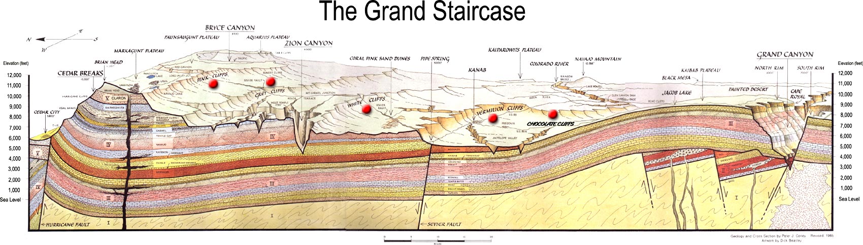
I have one very simple argument about that which is based on cross sections of the Grand Canyon - Grand Staircase area that runs from Arizona to Utah.

I've been unable to load any images into my blogs for some time so all I can do is paste a link to one of these cross sections:

Grand Staircase image

This shows the depth of the layers of rock at the north end of the Grand Staircase to be about two miles, and the number of layers to be roughly about 26.  Clearly these layers were originally continuous at that depth for more than two hundred miles to the Grand Canyon area and beyond, but the strata above the Kaibab level eroded away over the Grand Canyon and chunks of the strata above that level also eroded away in the Grand Staircase area, forming the stairs of the staircase.

This shows that all those layers were in place at one time, and this fact is emphasized by the intrusion of the magma dike at the north end of the Grand Staircase which penetrates upward through the entire stack from bottom to top, showing that it did not occur before they were all laid down.   It is also shown by the fault lines that split the whole stack; It is also shown by the distortion of the whole stack as a block as it follows the curve of the mound over the Grand Canyon.  If that rise had occurred before they were all laid down, the upper layers that were laid down later would not have remained parallel with the lower block of layers but would have been horizontal and butted up against the upgrades and curves.  That is not the case.  The entire stack as a whole follows the curves across the entire landscape, the layers all remaining parallel to one another.  It is also shown by the fact that the canyons and stairs were cut after they were all laid down.  Clearly they were all laid down and THEN there was a violent upheaval of some sort, tectonic force no doubt with attendant earthquakes plus the volcanic activity that is shown in the magma.  All this occurred TO THE ENTIRE STACK after it was all laid down.

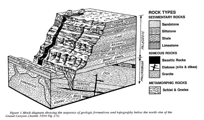
What is my point?  My point begins with the observation that according to conventional Geology each of those layers represents a time period of millions of years.   Here's another diagram  showing the time periods assigned to the layers in the Grand Canyon. Scroll down about half way to see it.   Really wish I could post just the image, sorry it's so awkward this way.

Now consider that conventional Geology describes the planet Earth as a "very active" planet, and ask yourself why in that case those strata are depicted as so neatly parallel over what adds up to hundreds of millions of years, how ALL of them were obviously laid down one on top of the other before the land was tilted, before the mounded rise formed, before the canyons and stairs or cliffs were cut, before the magma rose up through the layers and before the faulting occurred.

The obvious conclusion is that those hundreds of millions of years did not happen.  It's all a fiction.

When I presented this scenario at EvC of course I got all kinds of objections.  "Well but surely each of those layers would show a great deal of activity if you looked into them minutely" for instance.  But of course that doesn't answer why they ALL follow the same contours as a block.   And "Really there's nothing odd about there being no activity on the planet for hundreds of millions of years, and then a lot of activity all at once."  Really?   They also suggested that this could have happened in this particular area and nowhere else. To this I can only say that you also find blocks of strata everywhere distorted by tectonic force as a block. There is nothing quite like the Grand Canyon of course which shows the Geologic Column to such a great depth. And they objected to the use of a diagram at all, as if the artist wouldn't have known not to draw the strata parallel if they weren't parallel. And of course the usual objections were raised about the Young Earth arguments as well, which became a major distraction from the main point I was making. 

But this one simple observation stands against the whole Old Earth argument.  I think it's open and shut myself.

From there I go on to argue that the actual appearance of the strata in that area is much better explained by the Flood, and that gets into all kinds of other considerations.  But rather than lay those out here I just want to keep it simple, showing that the conventional explanation does not account for the actual formation of the strata.

And yes, there is The Great Unconformity at the base of the Grand Canyon too.  I believe that also occurred at the same time as all the other activity I've described, and there are some posts on this blog about it, but it's not necessary to insist on that to make the point I'm making here.  Many creationists treat the Great Unconformity as already there when the Flood occurred and laid down the strata above it.   I don't, but it doesn't interfere with the point I'm making here to leave it at that.

Saturday, October 15, 2011

More on the Flood, inadequate comparisons with local floods

There have been half a dozen posts at EvC recently, mostly on the Flood, that I've wanted to respond to but haven't been able to get to them, don't know if I will yet. But here's a new one:
Portillo says: Billions of dead things, which we call fossils, laid down by water all over the world.
And Panda answers: Although true: that is far too a general statement to be useful.

The following sentence is also true:

If 1000's of small floods occurred over millions of years, what would you expect to find? Billions of dead things, which we call fossils, laid down by water all over the world. And what do we find? Billions of dead things, which we call fossils, laid down by water all over the world.
Sorry, but this sentence is NOT true. Perhaps Portillo should have been more detailed in his remark but that probably wouldn't faze the sophists at EvC either. But anyway, No, from small floods even in the millions we could NOT get the billions of dead things that we find as fossils in the worldwide strata and we certainly do not get the depth and extent and amazingly consistent appearance of the strata themselves, an appearance that suggests to anyone really thinking that they all had to have been created in ONE event, not a series of events, and not a hodgepodge of little floods over time. This is just evo sophistry run amok.
There needs to be something to separate your claim from the more mundane floods that we see regularly, all over the world.

So, although correct, you statement needs to be more specific to rule out the everyday events.
As I've stated above.

And Dr. A adds his own two cents in the next post:
[Portillo]If a flood occurred, what would you expect to find? Billions of dead things, which we call fossils, laid down by water all over the world.
[Dr. A]Why? Is mass fossilization the usual sequel in the locale of a localized non-magical flood? Please provide evidence that this is the case.

If not, then I would have no such expectation.
Interesting. He's implying a disagreement with Panda's implication that local floods COULD have produced all those fossils. He's right, they could not. Mass fossilization is NOT the usual sequel to local floods, there is no comparison, which just highlights Panda's sophistry.

But he's also committing the error of thinking the Flood of Noah can be compared to local floods. About the only effect that they can be used to demonstrate is the destructiveness of even small floods, which ought to get across that there had to be huge effects from the worldwide Flood. And there are: The entire world has a wrecked and tumble-down appearance, but also the strata and the fossils around the world testify to it to anyone with eyes to see. NOTHING could have created all that BUT the Flood of Noah.

Earlier in the same thread Dr A responds to someone's claim that the Channeled Scablands of Washington show what would happen in the Flood:
[Coyote]One example of this is the evidence left by the Channeled Scablands of eastern Washington.
[Dr. A] I think I've expressed my doubts about the Channeled Scablands before, but this is a new thread, so I'll do it again.

The snag is that they were caused by the breaking of a natural dam so that a lot of pent-up water swept laterally across the landscape. Rather than by a lot of rain. Sure, it's a catastrophic flood, but is it a good model for the Flood
And in another post down a bit:
[Coyote] The massive amounts of rain would quickly seek lower levels, and we know from recent disasters how devastating that can be.
[Dr. A] Devastating, yes. Producing channeled scablands, no.
And if I'm following this correctly -- it's not as clear as it might be-- he's right, the Flood would not have created the Channeled Scablands. The Flood wouldn't carve land like that, simply destroy it, at least in the initial stages from the heavy rains -- but the Flood and ONLY the Flood could have deposited the strata -- in a later stage. As current Geology convincingly says about the Scablands, they were created by the breaking of a dam that released a massive amount of water from a standing lake. THAT kind of water flow COULD carve such channels.

However, in a sense it IS still all the Flood's doing, as a Floodist regards that enormous lake, known as Lake Missoula, to be water left after the Flood had drained away, along with other giant lakes such as Lahontan and Bonneville in the same general area. It's also seemed to me that a trigger for the breaking of the dam and the release of the water from not just Missoula but all the lakes could likely have been the tectonic forces that came into play some time after the Flood. They built the Rockies, pushed up the land, could have dumped the lakes as well. Something like that is surely what carved the Grand Canyon and Grand Staircase area. The canyon appears to have been formed first by deep volcanic eruption which raised the land in that area and cracked the upper strata which had been laid down to a depth of two miles or more originally. That admitted the residual standing Flood waters as an enormous cataract pouring in from all sides of the crack. Certainly something like that had to have been the case. The Colorado river even swollen to the max could not have done such a thing in billions of years.

LATER ADDITION:
Then Coyote, who repeats his mantra about the age of the strata and the fossils because he can't think any other way. He regards it all as fact to such an extent that his mind can't even produce a contrary thought.

Anyway, here's his comment:
If a flood occurred, what would you expect to find? Billions of dead things, which we call fossils, laid down by water all over the world. And what do we find? Billions of dead things, which we call fossils, laid down by water all over the world.
One problem with this scenario is that these fossils are spread over a billion or so years; they are far from being the same age.
Sorry, we believe your methods of dating are all wrong, don't believe a word of it. They ARE all the same age, you just have to learn to see with new eyes.
Another problem is that we can see evolution in the fossils. These layers of different ages show a progression of critters from older to younger. This progression had to take a lot of time to develop.
They SEEM to but you are of course ignoring anything that contradicts that perfect scenario and you are INTERPRETING the differences between varieties of the same type to be evolution of that type when all they are is VARIETIES that form from the BUILT-IN gene code for that species. Trilobites for instance obviously had a broad range of variation possible built into their genome. And there is really nothing about them to justify your categorizing those higher in the strata as younger or "more evolved" than those lower, that's just an artifact of your theory / figment of your imagination. I'm sure you can rationalize it but without any real justification, only by noting certain factors while ignoring others. And if you are talking about different species in the sense of Kinds (they're called something different from the other species) being older or younger with respect to each other, again that is PURELY an artifact of your theory, something you can possibly rationalize by making certain comparisons and ignoring others, but in reality they are simply SEPARATE SPECIES with their own species-specific gene code.
Also, floods don't produce fossils.
That is true, the ordinary everyday floods that go on in our time do NOT produce fossils. But the Flood of Noah did, because it moved such prodigious amounts of sediments and living things and deposited them in such thick layers all over the earth it created the ideal conditions for fossilization.
Shellfish fossils are produced in oceans, and sometimes lakes or marshes.
HOW DO YOU KNOW THAT? Meaning what is your evidence. But of course one would expect seashells to come from the ocean so that part's obvious. But the FLOOD WAS AN OCEAN FER PETE'S SAKE. You know, ALL THE WATER ON THE PLANET KINDA SORTA MINGLED TOGETHER IN THAT EVENT. As for "sometimes" lakes or marshes, HOW DO YOU KNOW THAT? Kindly give us the evidence that any lake or marsh since the Flood has produced a fossil. I don't say it's impossible, only that any of the billions of fossils in the strata were NOT produced by a lake or a marsh.
The most a flood could do is move a fossil.
This was not just "A FLOOD," this was THE Flood to end all floods. It did not MOVE fossils, it MADE fossils.
Ignoring the two problems above, what are the odds that the fossils could be ripped up from their original locations and sorted out by time and type in their new locations by chaotic flood waters?
The fossils weren't, but the question applies somewhat to the living things themselves that were buried by the Flood. The TIME element of course does not apply, that's just your usual presupposition that you can't seem to suspend even for a moment's consideration of another point of view, but the sorting by type is mostly a SEEMING sorting by type as I say above. However, the Flood wasn't as chaotic as you seem to think. Ocean water has layers and currents and streams in it and these carry things. We can only suppose that the living things were sorted by some physical factors as well as their original habitat and their having been found all together in one place at the time of the Flood.

===========
And now Nuggin following Coyote:
If a flood occurred, what would you expect to find? Billions of dead things, which we call fossils, laid down by water all over the world. And what do we find? Billions of dead things, which we call fossils, laid down by water all over the world.
When floods occur, they kill everything that can not get away. They sweep all the dead things downhill to form giant piles of dead things.
As is the case with most here, you are picturing an ordinary flood limited in space and time compared to THE Flood which covered the entire planet and lasted a year. It rained 40 days and 40 nights during which time mudslides would have occurred and living things would have sought higher ground, most likely flocking together in their own groups. When they are swept up in a mudslide they are all together with perhaps the odd misfit as well. They do not form just a bunch of giant piles because there is too much water. Some may stay buried but as the water rises it's going to continue to erode away the land including all the mud with the dead creatures in it and carry them in the water along with the sediments. We know water sorts sediments, and apparently there was enough of it in the Flood that it also sorted everything else and carried it along in its layers and currents and streams until whatever law of physics came into play at whatever was the right phase of the Flood and dropped them on the now-denuded land mass in interestingly separated layers of sediments with their peculiar creaturely contents.
Those dead things are not sorted.
Not in an ordinary little local flood. Think bigger, Nuggywuggy.
If you flood Upstate New York, you are going to get dead people, dogs, cats, horses, cows, deer, coyotes, raccoons, mice, rats, snakes etc. All the things in the environment.

When we look at fossil beds we do not see a vast collection of "everything". We see certain groups of things clustered together and then other groups of things clustered together in different strata.

If "The Flood" were to occur, we'd expect to find elephants AND mammoths AND mastadons AND rabbits AND T-Rex AND zebras all in one big piles
We never find that. Ever.

So, unless "The Flood" included magic sorting water, your claim just doesn't.... carry water.
. Yeah well you've got the usual commonsense notion based on no knowledge whatever or even a reasonable imagination of what a worldwide Flood would do that lasted an entire year, just the usual itty bitty flood you've seen with your own eyes on television. And it has its plausibility as an exercise of fallible human imagination but that's all it has.

Actually your objection to the way things are sorted is just as much an objection to the evolutionist explanation. OK you've got the strata sorted VERTICALLY into time periods so you can get away with explaining the sorting of the fossils in terms of time, but there's nothing in evo theory that accounts for the HORIZONTAL sorting that is also seen in the strata. There is some mixture, sure, but there are also whole beds of one family of creatures from trilobites to dinosaurs, sometimes so ridiculously packed together the idea that they died in anything other than an enormous catastrophe is just ludicrous. Why should that be? Do animals all go to the same place to die? Not in our world. They die willy nilly just as you picture those creatures from New York dying in your tiny little flood.

No, SOMETHING sorted all of it. Seems to me the Flood is the only reasonable explanation. Something to do with the characteristics of a huge body of water, not magic.

Wednesday, September 14, 2011

A little exercise in fantasy science

(This entry has been heavily rewritten since first posting.)

Typical "Scientific" Mystification as expressed at Wikipedia about the supposed formation of the Grand Canyon:
Geology of the Grand Canyon area
From Wikipedia, the free encyclopedia

The geology of the Grand Canyon area exposes one of the most complete and studied sequences of rock on Earth. The nearly 40 major sedimentary rock layers exposed in the Grand Canyon and in the Grand Canyon National Park area range in age from about 200 million to nearly 2 billion years old.
Considering the highly speculative history of determining the age of rocks you'd think they'd be a little more circumspect in their oh-so-definite assertions of this sort.
Most were deposited in warm, shallow seas and near ancient, long-gone sea shores in western North America.
Now I'm sure this is all based on an interpretation of some of the contents of the various strata but why do they only give us their conclusions in such flat-out assertive language instead of some discussion of how they arrived at it? What genuine Science talks like this? I'd really like to see the evidence for the warm shallow seas -- contents of the rocks that normally LIVE in warm shallow seas or what? And for the long-gone sea shores. Are there shoreline rings and that sort of thing somewhere? See, I'm a believer in the Flood, so I'm going to have a very different interpretation of whatever the evidence is that they interpret as warm shallow seas and sea shores. For instance, if it's the fossil contents of the rocks that lead to warm shallow seas because that is those creatures normal habitat when alive, the Flood interpretation would say that they were carried there and died there and didn't live on that spot. If there is evidence of old shorelines near the Grand Canyon, I have no doubt they represent a body of water that was left standing after the Flood for some period of time, long enough to leave the shoreline marks.
Both marine and terrestrial sediments are represented ...
Ah, a factual statement amidst the fantasy. That goes nowhere though. I'm sure they can say what makes the sediments marine or terrestrial, but if they were transported there on the Flood all that distinction refers to is their place of origin. It certainly wasn't the walls of the Grand Canyon.
...at least including fossilized sand dunes from an extinct desert.
And now back to speculative interpretion. You know this how? Your evidence is what? Any creationist writing like this would be scathingly dismissed as an idiot. Again, whatever the evidence that leads them to fossilized sand dunes, their sand had to have been transported on the Flood to their present resting place. And again, why don't they describe their evidence?
There are at least 14 known unconformities in the geologic record found in the Grand Canyon area.
Another of the very rare factual statements, presented without a hint as to their relevance or scientific import. Second thought: Depends on what sort of unconformity they're talking about. There is certainly a huge "angular unconformity" at the base of the canyon which I've discussed many times before, but there is also a purely fictional "unconformity" that is a "missing" layer, that is, a layer of fossilized sediment that their theory says is supposed to be there but isn't. Of course there isn't the faintest sign that such a layer was ever there; the strata are all just as neatly and tightly and horizontally stacked through those "periods" of "unconformity" as everywhere else in the column.
Uplift of the region started about 75 million years ago during the Laramide orogeny; a mountain-building event that is largely responsible for creating the Rocky Mountains to the east. In total the Colorado Plateau was uplifted an estimated 2 miles (3.2 km). The adjacent Basin and Range province to the west started to form about 18 million years ago as the result of crustal stretching. A drainage system that flowed through what is today the eastern Grand Canyon emptied into the now lower Basin and Range province. Opening of the Gulf of California around 6 million years ago enabled a large river to cut its way northeast from the gulf. The new river captured the older drainage to form the ancestral Colorado River, which in turn started to form the Grand Canyon.
You see how they talk as if this is observed fact rather than
interpretation of various geological formations. Obviously we're expected to just sit quietly and receive it unquestioningly as revelation from Those Who Know, without a discussion of how they arrived at it, without evidence or anything to engage us in thinking about it.

Anyway, again, I would really like to know what the evidence is for this mountain building period, and actually I don't doubt that there IS evidence, what I doubt is their interpretation of the evidence. Especially of course the time factork, how it got associated with a particular block of sediment layers. And I love thinking about this stuff. I've many times wondered about the formation of the Great Basin as well as the Grand Canyon, love to look at maps that show the topography clearly.

The interpretation from the Flood perspective includes volcanic and tectonic activity as part of the Flood event, perhaps causing it to some extent or caused by it, in any case associated with it. It's frustrating to read the descriptions from the establishment point of view that don't provide enough fact for a Floodist to think about. All you get is the Official Party Line. If I could afford a good geology book or an online course in geology MAYBE it would give the evidence behind such things? Or maybe not -- probably not part of a basic course. Ideally one could ask a geologist about all these things but they are a prickly bunch with creationists. For all their supposed interest in educating us stupid creationists at EvC, if you start asking questions to clarify such things for your own purposes, forget it, they don't want to give you a free education, go take a course.
Wetter climates brought upon by ice ages starting 2 million years ago greatly increased excavation of the Grand Canyon, which was nearly as deep as it is now by 1.2 million years ago. Volcanic activity deposited lava over the area 1.8 million to 500,000 years ago. At least 13 lava dams blocked the Colorado River, forming lakes that were up to 2,000 feet (610 m) deep. The end of the last ice age and subsequent human activity has greatly reduced the ability of the Colorado River to excavate the canyon. Dams in particular have upset patterns of sediment transport and deposition. Controlled floods from Glen Canyon Dam upstream have been conducted to see if they have a restorative effect. Earthquakes and mass wasting erosive events still affect the region
What might have some basis in reasonable deduction from evidence is so mingled with what is most likely sheer conjecture based on nothing but assumption, and the possibly reasonable deduction is presented so utterly devoid of evidence for it in any case, EVERYBODY should object to this sort of thing, not just creationists. But no, anti-creationists accept it as wisdom from on high and offered as science, expect a creationist to swallow it without question or else be branded an anti-scientific ignoramus. How ironic, how sad. I really want to see the signs of the lakes that were backed up behind lava dams, what traces did they leave? What is the evidence of ice involvement?

Well, the rest of the article goes on in the same vein, a mix of a few facts that just stick out like islands among one description after another of purely fantastical ancient deserts and seas and so on that of course nobody was there to witness and can therefore be nothing but speculation based on who-knows-what, and the who-knows-what is of course not given, because this is NOT science, this is Fantasy.

Sigh.

Here's a thread of my own at EvC that spun off one on the Grand Canyon, in which I take pains to be clear about what I mean about the difference between conjecture and fact. Unfortunately here and there I wasn't quite as clear as I thought I was being and I'd make some changes now, but the basic idea is still there. But all anyone did in response to my pains was make absurd straw man arguments.

I'll try to state it again now:

The reason references to ancient landscapes, deserts, inland seas and whatnot are conjecture as opposed to fact is that there is no way to validate (or invalidate) the interpretation. It conjures up a scenario in the distant past that is described almost as if it had been seen, but nobody witnessed it so there is no way to corroborate the conjecture; it remains forever a conjecture although they treat it as a fact.

There's nothing wrong with conjecture of course, it's the normal first step to a scientific explanation; perhaps it should be called a hypothesis. The problem is that any other possible interpretations of the same facts that led them to a particular conjecture are pre-empted when they don't bother to describe the facts and that renders the favored interpretation unfalsifiable.

Exactly what is the factual evidence that leads them to the scenario of an inland sea on the North American continent, for instance? I'd really like to know but that part they normally leave out of the discussion. Of course I suspect that "inland sea" would be well interpreted as a stage of the receding Flood. A slow-draining leftover body of water could probably explain the facts quite nicely if only the facts were available. Not a sea that stood for millions of years, but perhaps weeks or months or a few years.

Someone on that old thread compared my argument to an argument whether the claim that Henry the 8th was King of England was fact or conjecture. There is no comparison and it was irritating to have someone try to hang that on me. Henry the 8th had witnesses galore, histories written about him and no doubt all kinds of vestiges of his existence and influence remain in English institutions as well. Paintings of his royal self abound. Show me a photo of the ancient landscape you've conjured up. An "ancient desert" has NOTHING from its own time to show for itself. Henry the 8th had corroborating evidence; inventions of ancient scenarios have nothing to corroborate them. And really, it is STUPID to make such a comparison.

Where's the data that should be available to scientists who want to test your theory? Laboratory science is replicable by anyone. This kind of "science" remains conjecture forever although ordained as Fact.

Monday, August 8, 2011

Dealing with some arguments against the Flood

D Wise who posts at EvC forums has his own site on the debate, or really, on what's wrong with creation science. He's amassed quite a collection of arguments against creationist arguments, many against the Flood. This is an improvement over the endless refrain at EvC that the Flood has been discredited many times over although most of the time all they offer is that refrain and leave it to the reader to figure out what evidence they have in mind. So it's helpful to see all the arguments mustered in one place, as D Wise does on this page.

It's a formidable collection and I'm sure I won't be able to address more than a few of them, but I'd like to do whatever I can, and I'll take them in the order he's presented them:

First, I just want to note that he's extremely offended at the statement of belief made by the late Henry Morris of the Institute for Creation Research:
Notice that they [some Christian geologists] suffered severe crises of FAITH, not of GEOLOGY! This should not come unexpected, considering Dr. Henry Morris' teachings about geological evidence, teachings which the ICR lives by:
"No geological difficulties, real or imagined, can be allowed to take precedence over the clear statements and necessary inferences of Scripture." (_Biblical Cosmology_, page 33)

"The data of geology, in our view, should be interpreted in light of Scripture, rather than distorting Scripture to accommodate current geological philosophy." (_Science, Scripture, and the Young Earth_, page 6)
In short, if it don't fit our theology, then either make it fit or ignore it. To that, his son and heir apparent, John Morris, has added (and many at the ICR seem to concur and actively teach): if it refutes the smallest part of our theology, then it disproves our entire theology. No wonder those students suffered so at seeing their faith crumble before them; this is one of the more distasteful and destructive consequences of the "Dark Side of the Farce."
Of course we can't expect an unbeliever to grasp the importance of the credal statement by Henry Morris, but all Christians should certainly embrace it -- it is the Light while the Dark Side is the offense taken against it. The Bible is God's word, not to be subjected to dissent or argument, that's the nonnegotiable foundation. And yes, we either have to find a way to reconcile science with it or simply leave science alone until enough is known to make the reconciliation. There is no other alternative, whether Wise and other unbelievers find this "distasteful and destructive" or not. Our faith and the world will always be at enmity.

Of course this assumes RIGHTLY reconciling science with scripture, although Wise accuses creationists of all manner of dishonesty, and I'm not going to get into that because I haven't followed all the creationist claims. The one time I specifically asked an evolutionist for an example of such dishonesty he described what was really only a confused wrong idea about what evolution teaches, not dishonesty at all. In fact I haven't yet seen an example of what I would have to agree is dishonesty. Not that it doesn't exist, I wouldn't know.

So I generally avoid those issues, but I'll weigh in on the basics. One of the basics is that God's word trumps ALL. Period.

That said, on to the science issues (I've added the headlines):

TIME NEEDED TO FORM GRANITE AND METAMORPHIC ROCK

Also speaking at the 1986 ICC was Harvard paleontology graduate student Kurt Wise (no relation, I'm sure), who surveyed what is known about the speed of formation of the three major kinds of rock. While he found that many kinds of sedimentary rock can form rapidly, igneous rock is another matter. While a small chunk of granite can conceivably form in a short time, many massive bodies are known, such as huge granite batholiths, some of them 10 kilometers in diameter, in the White Mountains of New Hampshire. Under the most favorable conditions, such formations would take about 100,000 years to cool, instead of the 6000 to 8000 years required by Flood Geology. Metamorphic rock is worse since it must first be formed as sedimentary rock, be heated, and then cool off.

During the question period, geophysicist John Baumgardner pointed out that Wise's figures had been very conservative and that much more time would be needed for rocks to form. He also offered sheer forces as a source of heat and pressure for metamorphic rock, but Wise countered that many metamorphic rocks show no signs of sheer.
[It's "shear" but anyway]. As I've been refining my view of the formation of the Grand Canyon I came to the question of how the granite and schist at the base formed. I've explained the Great Unconformity at the base as brought about by the volcanic eruption that is evidenced by the magma (granite) intrusions in all the illustrations as well as by the uplift of the area of the canyon itself, and logically the granite and metamorphic rocks were also formed by the same eruption.

There's heat and pressure generated by the volcano plus the weight of the strata overhead for that part of the transformation -- the metamorphic rock or in that case the schist -- and if all this occurred while the Flood waters were still on the earth, which I'm arguing was the case, there would have been plenty of water everywhere to exert a cooling effect on the rising magma. The strata would be saturated and oozing water for some time to come, a cooling effect on the order of a gigantic Wet Blanket some two to three miles deep in the Grand Canyon area.

I don't know about New Hampshire but granite batholiths form deep in the earth under the same blanket of strata everywhere -- there are many illustrations on the web that demonstrate this. They spread out horizontally to great distances, apparently kept from pushing upward by some barrier above, such as a few miles' depth of wet sediments. The magma does also push up through the strata in separate fingers that cool to dikes over time, burning through all the layers to the surface where lava overflows and making horizontal "sills" of magma between layers on the way up. (The computer I'm using doesn't have enough power to allow me to post some diagrams but eventually I'll try to put some up).

The batholiths would be relatively thin vertically and in contact with the wet rock above for their entire horizontal extension. The rock immediately above would heat up from contact with the magma, even while exerting a cooling effect in return, but there's plenty of water above that point of contact to keep trickling down through the layers to continue the cooling effect for a great while to come. Eventually the magma would be cooled to granite batholith, which it seems to me would occur appreciably faster under these conditions than the usual calculations take into account -- they assume dry rock -- though no doubt not nearly as fast as lava cools on the surface.

More to come from D Wise's list of arguments.

=====================
Yes, I know geologists are used to encountering water underground. Would they recognize the effect of a few miles' worth of damp sediments on rising magma that occurred over 4000 years ago? And how would they recognize it?

Email correspondent gave me some calculations about how the weight of the strata wouldn't be sufficient to form metamorphic rock within the time span I'm allotting, or to cool the magma I think he also said but I'll have to reread it to be sure. Somebody is going to have to translate the math into descriptive English if they want me to accept any of it. For all I know it doesn't represent the situation I have in mind at all.

Friday, May 13, 2011

Angular Unconformities: An Alternative Interpretation Part 2: Charles Lyell Proves My Point

Now I want to go into more detail in the attempt to demonstrate that angular unconformities are created after the whole stack of layers is laid down, which contradicts the current interpretation of angular unconformities as gradually developing and requiring a very long time to form.

Since the Grand Canyon - Grand Staircase area has the advantage of showing pretty much the entire Geologic Column from "Precambrian" to "Quaternary" or "Recent" rock, it makes the best display of undisturbed horizontality of ALL the strata up through the entire stack. The whole area was clearly completely undisturbed until the canyons and cliffs were cut into the strata and the area was raised and tilted and mounded, all probably brought about by the volcanic activity in the area. Even this activity didn't disturb the strata for thousands of miles, it merely slightly tilted and cut into them.

The Great Unconformity at the base of the Grand Canyon I've already explained as most likely caused by the same volcanic force AFTER all the strata were in place. It's an educated conjecture in that case (just as the build-tilt-erode-build interpretation is conjecture), but there is another angular unconformity in the region that I think clearly shows that it had to have been created in that order. Here are some diagrams:


Click to see enlarged. This is an official government drawing showing the whole area from the Grand Canyon through the Grand Staircase.

Below is the north end of the Staircase from this same diagram showing the angular unconformity to the north of the Hurricane Fault. This unconformity was apparently created by the slipping of the fault line. The land dropped about 4000 feet and tilted the strata both against the nearly-vertical fault line and against the layer above marked “V” which remains horizontal.

Perhaps this section fell simultaneously with the raising of the main body of the strata. Probably the volcanic eruption indicated in the magma dike which exits in a lava flow at the very top of the Staircase was the cause of the whole displacement.

Since we see the same stack of strata on both sides of the Hurricane Fault, in the same order, but one side is tilted except for the horizontal Clarion layer “V” and the other is continuous, all parallel, this ought to suggest that the unconformity was created in one event. This should bring into question Hutton’s interpretation of angular unconformities as requiring a great deal of time for tilting and erosion before the laying down of new horizontal strata. In this case the horizontal layer was almost certainly already there as it is continuous with the one to the right above, and the whole structure appears to have been formed in one event.

I've been trying for some time to come up with a good model for how I think this happens -- that is, how lower strata could be folded or tilted beneath higher strata without disturbing the higher strata -- and although I can describe it I can't think of practical examples that demonstrate it.

The example comes to mind of the trick of pulling a tablecloth out from under a full table setting of dishes and cups and so on without disturbing them and that does demonstrate that force can be applied to an object beneath other objects without disturbing them. The conditions required for this to work would be heavier solid upper objects and more flexible lower objects, which is exactly what I have in mind, but of course this example doesn't exactly DO what an angular unconformity does. There must be many other examples but I keep drawing a blank.

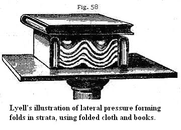
I've also imagined an experiment with modeling-clay strata but that's really beyond my means to set up and it would be much too hard to recreate anything like the circumstances of the actual strata on such a small scale. But then I found a description of exactly that sort of experiment having already been done, in Chapter 5 of Elements of Geology by Charles Lyell, friend of Darwin and popularizer of Hutton's theory of a very old earth and the principle of uniformitarianism. He was trying to explain how folded strata form, such as in this sketch on the same page:


Folding by Lateral Movement.—An experiment was made by Sir James Hall, with a view of illustrating the manner in which such strata, assuming them to have been originally horizontal, may have been forced into their present position. A set of layers of clay were placed under a weight, and their opposite ends pressed towards each other with such force as to cause them to approach more nearly together. On the removal of the weight, the layers of clay were found to be curved and folded, so as to bear a miniature resemblance to the strata in the cliffs. Chap 5, p. 76
I've been looking for a way to illustrate the upright tilting of strata but this experiment demonstrated how they are folded or buckled. It's very important for my purposes that he placed the clay layers under a weight before applying lateral pressure. Lyell doesn't explain this but it seems intuitively necessary to do this. What I've been claiming is that the weight of strata above is a necessary resistance to the tilting of the strata beneath in the creation of angular unconformities; that is, the strata above would have to have already been in place before the tilting occurred, as opposed to the accepted theory which puts the tilting first, then erosion, then the laying down of strata above. The heavy and horizontal weight overhead would force the tilting or folding strata to form a horizontal upper surface, probably the result of violent erosion from friction between them and the upper layer as the force was applied.

On the present theory it's hard to see how tilted strata without a weight overhead could be anything but very irregular and jagged. And this is also where I question the idea that erosion at this point would level such a formation. I also question the idea of a hiatus or time gap during which the strata are no longer forming. What could cause that cessation? And if the strata did keep on forming after such a tilting of strata the new sediments would be forced to settle in the crevises between the jagged or folded uprights, they wouldn't just neatly arrange themselves in a new horizontal layer lying flat across the top of them.

Lyell even explains the absence of upper horizontal strata in some such formations this way:


the ... upper portion, being supposed to have been carried away by denudation, or that action of water which will be explained in the next chapter.
He next discusses an experiment which comes even closer to what I've been envisioning:


We may still more easily illustrate the effects which a lateral thrust might produce on flexible strata, by placing several pieces of differently coloured cloths upon a table, and when they are spread out horizontally, cover them with a book. Then apply other books to each end, and force them towards each other. The folding of the cloths (see Fig. 58) will imitate those of the bent strata; the incumbent book being slightly lifted up, and no longer touching the two volumes on which it rested before, because it is supported by the tops of the anticlinal ridges formed by the curved cloths. In like manner there can be no doubt that the squeezed strata, although laterally condensed and more closely packed, are yet elongated and made to rise upward, in a direction perpendicular to the pressure.
I would never have thought of using CLOTH, but it makes the point beautifully. Again a weight is placed above and the "strata" are shown to buckle just as real strata do under the weight with pressure applied from the side.

Lyell has accepted Hutton's view of an old earth and his principle of uniformitarianism, so throughout this book he assumes extremely slow processes for all the formations, but what's interesting is that he pictures a weight over the folding and tilting strata as essential to the explanation, and that contradicts Hutton's idea that the strata were FIRST tilted and THEN the upper strata were laid down over them. In fact that was essential to Hutton's idea of an old earth and now Lyell has shown that it's not necessary at all, apparently without grasping the implication that an old earth is not needed to explain these formations.

As you read on in this chapter of his book you find him showing how upright strata were probably originally folded, giving some good examples, including one of Siccar Point as part of a larger formation that includes such folded strata. He then describes the unconformity at Siccar Point in Hutton's terms:


...it is evident that a period had elapsed between the production of the two sets of strata, and that, during this interval, the older series had been tilted and disturbed. Afterwards the upper series was thrown down in horizontal strata upon it.
The model of the cloth strata between the books shows that this is most likely not the real order of events, that the weight of already-existing upper horizontal strata would have been necessary to the formation of the tilted strata.

I've also been imagining a tilting following a breaking of lower strata, but Lyell brings up the very likely possibility that the lower strata were originally folded and the bent or folded section was lost. He discusses only the case of their being lost through water denudation, but in the examples I have in mind they'd have been sheared off in the process of being forced under a resistant horizontal weight of strata above them. After the shearing what is left is simply tilted strata without evidence of the prior folding. I still think it possible that in some cases there was first a breaking and then a tilting and shearing off without folding. In fact I think that's most likely what happened in the angular unconformity illustrated above at the far north of the Grand Staircase. Maybe Lyell even considers that somewhere. His book is quite a tome but I expect to keep reading it.

So, the explanation for the unconformity at Siccar point is that there was originally a great depth of horizontal strata there just as there was everywhere else around the world after the Flood of Noah. Then tectonic or volcanic forces tilted or folded a block of the LOWER strata, which were sheared off at the top under the weight of higher strata that remained horizontal though they may have been raised by the force. Then it was probably the rush of receding Flood waters that scoured off the layers above those that remain. And the same thing occurred in the formation of the Great Unconformity at the base of the Grand Canyon except that a huge depth of strata remained in place above it, as only the very highest strata, those above the Kaibab layer that continue in the Grand Staircase to the north, were scoured off by the receding Flood waters.

I really think we could put QED to this here. Lyell himself in the very act of supporting Hutton's idea of extremely slow geological formation ignores Hutton's own inciting example in favor of an example that demonstrates that lower strata can be deformed under strata that remain horizontal, which does not require millions of years, but could easily have occurred in the time frame of the Flood of Noah and subsequent tectonic and volcanic pressures afterward.
==========================================================


***Blog Post Powered by Prayer***

This one was definitely powered by prayer more than others I've done as I was struggling to find the best models for what I've been envisioning and the Lord answered prayer for those models by leading me to Lyell's book, the most striking example being the cloth strata, but I credit the Lord for all the other ideas as well. I couldn't think a useful thought without his guidance. Of course, all errors are my own.

Sunday, May 8, 2011

Angular Unconformities: an Alternative Interpretation Part 1: Siccar Point

Geologist James Hutton's [1726 - 1797] drawing of Siccar Point (actually James Hall's, who was with Hutton), and a recent photograph:

Siccar Point, Scotland, is where James Hutton decided that the Earth had to be very old and set the ball rolling for that to become the standard assumption of geology, overturning all previous assumptions of a young earth. His conclusion was that the more-or-less horizontal rocks on top of the vertical rocks had to have been laid down long after the vertical ones were in place, as it would take a huge amount of time for the lower to have been laid down, then tilted upright, then eroded before the upper were deposited on them. This kind of formation is known as an angular unconformity and it is considered to be lethal for Young Earth Creationism.

According to Wikipedia:
Siccar Point is a rocky promontory in the county of Berwickshire on the east coast of Scotland. It is famous in the history of geology for Hutton's Unconformity found in 1788, which James Hutton regarded as conclusive proof of his uniformitarian theory of geological development.
And according to a University of Wisconsin article:
One day in 1788, he and some friends rented a boat and sailed along the coast, discovering the rocks here at Siccar Point. The younger sandstones are resting atop vertical beds of older rock. The older rocks must have been deposited horizontally, tilted, eroded, then buried by the younger rocks.
As I recall from a biography of Hutton he was familiar with the formation already but he and his friends went out looking for it to verify the theory he was concocting in his head about it.

As the theory has it, "the older rocks must have been deposited horizontally, tilted, eroded, then buried by the younger rocks."
The vertical rocks are now known to be about 425 million years old and were deposited during the Silurian Period. They were tilted during a mountain-building event caused by the collision of North America and Europe. In North America the collision created the northern Appalachians. In Europe it is called the Caledonian Orogeny (Caledonia is the old Latin name for Scotland.)The mountains were eroded flat and the younger rocks were deposited during the Devonian Period about 345 million years ago, about 80 million years later.
I accept the explanation that it was tectonic movement that caused the tilting of the lower layers, the same movement that built the Appalachians, but I believe it was the jerky breaking apart and pulling away of North America from Europe that did it, as well as the volcanic eruptions that brought about the split, not a collision. There is plenty of evidence of ancient volcanoes in Britain and western Europe as well as along the east coast of North America.

And the theory is reiterated: "The mountains were eroded flat" and new horizontal strata were laid over them some 80 million years later.
...The contact at Siccar Point is called an angular unconformity, a place where an interval of geologic time is not preserved, and where the lower rocks have been tilted so they form a sharp angle with the overlying rocks. Hutton's Unconformity at Siccar Point is one of the most spectacular examples in the world as well as being of great importance in the history of geology.
Here's a diagram of The Grand Canyon showing the angular unconformity at its base.

Here's a page showing a few of the famous angular unconformities. The theory is affirmed in the description of the Entrada formation:
This unconformity (a buried erosional feature) formed when folded rocks of the lower formation (Entrada) had been eroded to a relatively flat surface before the sandy basal conglomerate of the Morrison formation were deposited on and buried this erosion surface.
"A buried erosional feature."

Here are some animations of the current theory about how angular unconformities are formed:

Exploring Earth Visualization.

There are two series of animations on this page that include the formation of a nonconformity as well as an angular unconformity.

And here's another animation of the angular unconformity

The sequence is identical in all cases. You see the buildup of horizontal strata, then the tilting of the strata, then the erosion of the surface to a relatively flat plane on which new horizontal strata are built.

This online book Telling Geologic Time, is nicely done and gives some clear illustrations of the current theory. The following diagram comes from this book and includes the same steps as in the above-noted animations of how angular unconformities develop.


This diagram shows the theoretical erosion part of the process, the erosion of the buckled strata more or less flat. Again, the process as current geology visualizes it it involves the laying down of flat horizontal strata, followed by a buckling of the strata, followed by an erosion of the surface that more or less levels it, followed by the laying down of more flat horizontal strata.

MAIN OBJECTION TO THIS THEORY: COGNITIVE DISSONANCE HERE: SINCE WHEN DOES EROSION EVER RESULT IN A FLAT PLANE SURFACE? Even a "relatively" flat plane surface? Since when would erosion reduce a mountain or a buckled block of strata to a plain?

The diagrams based on the theory all show a leveling of the elevated parts of the buckled strata. The idea seems to be that even mountains are ultimately eroded utterly flat, like a plain, so buckled or tilted strata with all their protuberances are expected to have been eroded down to flatness.

In what universe?

ON THE CONTRARY, erosion follows gravity, making paths down hills from summits, carving stream beds and gullies, transporting rocks and other debris and depositing them hither and thither, even in this way transforming plains into pocked and pitted and lumpy bumpy terrain, the OPPOSITE of what is claimed by these diagrams. Erosion also has an easier job of it with soft rocks and not so easy with hard ones -- and strata contain both soft and hard rocks. No way normal erosion is going to neatly scour away a stratified mountain to a flat plain.

Funny how they assume that erosion would level the buckled strata and yet at the same time they believe an ordinary river carved the Grand Canyon. This is really quite funny.

The only time erosive processes would ever produce a plain would be in such a massive event as the Flood of Noah, when huge areas of the higher strata would break up under tectonic or volcanic disturbance and be scoured off the surface of a particularly hard lower layer by the receding Flood waters. This is what appears to have been the case with the formation of the Kaibab Plateau that extends from the rim of the Grand Canyon to the base of the Grand Staircase, and other parts of the Southwest where some remnants of the upper strata remain in the form of buttes and odd "monuments" and hoodoos and the like, while the surrounding terrain is flat.

But normal-sized rivers, even little streams, just cut gullies and deposit rocks and other debris that disturb flatness. Just happened to find this photo of erosion of the cliffs of Dover on Wikipedia: I think it makes the point.

One absurd idea that comes from this absurd theory is that the Appalachian Mountains are "older" than the Rockies or the Himalayas, even that the Appalachians were "once higher than today's Himalaya mountain range."

No, they are different kinds of mountains. Both formed by tectonic forces no doubt, but the Appalachians are rather gently buckled compared to the Rockies, which appear to have been abruptly thrust up toward the sky in one massive movement that often preserved the strata's straight parallels if not their horizontality. The Himalayas also show such a cataclysmic origin, though I can't even find strata in pictures of them. The Appalachians never had jagged peaks that supposedly eroded away. Their strata are often gently buckled into anticlines and synclines. No amount of erosion would turn the Rockies or the Himalayas into Appalachian type mountains, and no amount of erosion could reduce the Appalachians to a flat plain either.

But that's of course a side trip.

BUT ALSO, WHY DOES STRATA-BUILDING STOP AND EROSION BEGIN?
Another question that occurs to me is why they so consistently assume that after the buckling of the strata there MUST be a period of erosion? Why? Why doesn't the laying down of sediments continue as usual? What magic wand was waved to stop that process? If the erosive period continues for as long as 80 million years, as apparently it's supposed to have done in the case of Siccar Point, before new strata are formed over the old, why aren't strata being formed during that 80 million years as well? What is it that would suddenly trigger erosive processes to the extent of being able to wipe out mountains in place of the usual processes of strata building? If strata just simply continued to be formed after the buckling of the previous strata then the new sediments would fill in the spaces in the buckled strata first. I'm not even sure there is such a formation anywhere to be found on the planet.

As there shouldn't be according to Flood theory, which shows that all the strata were put down at one time and buckling and other distortions occurred afterward.

Just another way the current theory makes no sense.

[Realized later that they assume the strata were laid down under water, tilted under pressure, then the land was lifted above the water and that's when the erosion began and the deposition of strata stopped. This raises its own questions but I realize it's at least necessary to acknowledge this much.]

SO HOW DID THE ANGULAR UNCONFORMITIES FORM?

1) All the strata had been built by the Flood.

2) A tectonic force from the side or a volcanic force from beneath (in the case of the Grand Canyon) tilted or buckled a block of the lower strata WITHOUT DISTURBING THE STRATA ABOVE THEM. Slippage between layers of different kinds of rock would facilitate such a movement, softer rock buckling under harder rock for instance. In the case of the Grand Canyon the volcanic force raised the whole area so that the higher strata follow the shape of the mounded elevation into which the canyon was cut, but even higher strata that were once there were cracked and broken by the force and washed away in the flood waters, leaving the Kaibab Plateau as the uppermost layer, a hard layer of limestone. Underneath, the volcano displaced the lowest strata which were met by the counterpressure of the heavy upper layers and simply tilted beneath them, creating erosion by the friction between them and the layer they are sliding under.

Same thing certainly happened at Siccar Point and other angular unconformities. One thing to notice about Siccar Point is that although a difference of 80 million years is assumed between the lower vertical and the upper horizontal layers, they look identically weathered and eroded. Speaking of what erosion is supposedly capable of, according to current theory, you'd think the entire block of vertical strata would have been reduced to the supposed flat plain well within the 80 million years allotted to it before the upper strata were deposited. At the very least they should look a lot more spindly and splintery than the upper strata in such a time frame.

TO BE CONTINUED.

Saturday, May 7, 2011

The K-T Boundary Fairy Tale

Starting at Post #37 this thread at EvC brings up some familiar debate issues concerning the evolutionist interpretation of the death of the dinosaurs.

The poster of message 37 is a creationist who says:
Its been a great gain for YEC creationism to have the impact thing arive to explain the great fauna/flora change in the world suddenly.
this creationist sees the k-t line as the flood line.
so what did for us is to demonstrate a instant die off and a dramatic and different recovery in a point in history.
We simply say this was the biblical flood.
A great die off and different recovery in fauna/flora.
The impact is simply misunderstood as to when it happened.
The layer designated by geologists as the K-T line or the line between the Cretaceous and the Tertiary time periods this creationist calls the "flood line." This is a popular choice for creationists who locate Noah's Flood not in all the strata but in some particular one.

If a creationist accepts any specific layer of the worldwide strata as the demarcation of the Flood he accepts the evolutionist belief that the strata represent time periods, that the geological column represents the history of the planet. But this is the very position a creationist should be opposing. The geological column is a museum of life forms that lived before the Flood. The strata could not have been formed except in such a cataclysmic event as a worldwide flood.

Evolutionists look at a particular layer of sedimentary rock which contains many dinosaur fossils and call it the Cretaceous period, and a block of layers above it which contains no dinosaur fossils at all, as the Tertiary. Floodists simply see disparate sediments with disparate fossil contents deposited by water in one cataclysmic event.

Here's a typical discussion of the K-T "event" at Wikipedia.
The Cretaceous–Tertiary extinction event, which occurred approximately 65.5 million years ago (Ma) at the end of the Maastrichtian, was a large-scale mass extinction of animal and plant species in a geologically short period of time. Widely known as the K–T extinction event, it is associated with a geological signature known as the K–T boundary, usually a thin band of sedimentation found in various parts of the world.
See how they describe something as a fact, a known reality, which is nothing but their own imaginative conjecture? This conjecture is based on a thin layer of iridium-rich clay between the sedimentary rock that usually contains dinosaur fossils and the rock above. They don't even bother to say something like "Scientists have conjectured that the iridium layer might indicate a mass extinction ..." The only clue they have to the possibility of an extinction event in the first place is the fact that dinosaurs don't occur above this line. In other words the whole thing is dictated by their theory that the strata represent time periods.
Non-avian dinosaur fossils are found only below the K–T boundary, indicating that non-avian dinosaurs became extinct during the boundary event.[3]
Yup, it's only the non-presence of dinosaur fossils above this line that leads to the extinction theory -- which, again, is described as a fact.

But the next sentence is also very interesting:
A very small number of dinosaur fossils have been found above the K–T boundary, but they have been explained as reworked, that is, fossils that have been eroded from their original locations then preserved in later sedimentary layers.[4][5][6]
See how easy it is for evolutionists to reinterpret something that doesn't fit their theory. If they found a rabbit fossil in pre-cambrian rock they'd come up with something similar.
Mosasaurs, plesiosaurs, pterosaurs and many species of plants and invertebrates also became extinct.
Meaning they too aren't found in the layer above.
Mammalian clades passed through the boundary with few extinctions, and evolutionary radiation from those Maastrichtian clades occurred well past the boundary. Rates of extinction and radiation varied across different clades of organisms.
All of which is describing only the presence or absence or rarity or abundance of fossils found in either location.

Here's another discussion of theK-T "event" as if it were a known fact:
One of the foremost problems that any successful theory of dinosaur extinction must explain is the fact that not just dinosaurs were affected. In fact, dinosaurs represent but a small portion of the species that became extinct at or near the end of the Cretaceous Period. The extinction event that brought the Cretaceous Period to a close (called the K/T extinction, where K stands for Cretaceous, and T for the Tertiary Era -- the Age of Mammals) was truly a "mass extinction," in that a wide variety of taxonomic groups from many different habitats were wiped out essentially at the same time.
It always helps to take any description of evolutionist fantasy and strip it of all the fantasy accretions down to the bare facts. In this case, ALL THIS MEANS IN TERMS OF ACTUAL KNOWN FACTS is that fossil creatures represented in this particular sedimentary rock that is called the Cretaceous Period do not appear in any rock above it. Their not appearing in any particular layer of sediments means NOTHING. Creatures were simply buried by the Flood in certain sediments and fossilized as the sediments hardened. In the case of dinosaurs, as with all land animals, a pair of them would have been on the ark. They may have survived for a while after the Flood and may have been the source of the various dragon stories across the world, but have since become extinct.
Life in the Ocean
Many of the groups of organisms that were hit hardest by the K/T extinction lived in the ocean. Ammonites and belemnites, shelled cephalopod mollusks related to the octopus and squid, were abundant in the seas of the Cretaceous Period, but had disappeared entirely by its end.
Again, all this means in terms of known fact is that there is an abundance of fossils of these creatures in the sedimentary rock misidentified as the time period "Cretaceous" that don't show up either in the rock above it or in the world today.
Another squid relative, the nautiloids, were also severely affected; only two species, the Chambered Nautilus and the King Nautilus, have survived to the present.
Do they show up in the strata above the Cretaceous or not? This ought to be the subject here, not merely whether they exist now.
Plesiosaurs, long necked, fish-eating marine reptiles, and mosasaurs, ferocious giant sea-going lizards, also vanished from the seas at this time... although their smaller land-dwelling reptilian cousins survived mostly unscathed.
FACT: fossils found in "Cretaceous" rock not found in strata above or living now either, except for the "smaller land-dwelling reptilian cousins."

Some creatures are found in fossilized form in specific layers and not at all in higher layers, but if they live today there's of course no reason to think of them as having gone extinct. But that's an interesting puzzle in itself -- if they exist only in some layers and not higher layers but do exist today, their not existing in layers they must have lived through -- according to the theory that those layers represent huge periods of time -- needs an explanation. But apparently this question only arises in creationists' minds as it calls the whole time period system into doubt; evolutionist geologists seem to be content to recognize fossils in only a specific layer even though none of them may appear in higher layers. Odd but true. Just one of the many ways science is blind to important questions that should falsify their theory.

Of course if the fossils were simply washed into their current beds by the great Flood all this is clearly nothing but fantasy, but worse than that it's fantasy forced on the public as fact, as the whole theory of evolution is


Here is a nicely simplified but typical example of an illustration of the Geological time scale showing the creatures whose fossils are found at each level of the strata, mislabelled of course as time periods.

So what does the layer of iridium suggest? Probably that the asteroid or comet which is supposed to be its source hit during the Flood and spread its iridium over the flood waters, which carried it along with some clay sediments to its current place between the dinosaur-fossil-carrying rocks and the higher mammal-fossil-carrying rocks. Perhaps it occurred in a late stage of the Flood since it is evidenced in the higher layers of the strata. OR, perhaps iridium from the Earth itself, although a rarity, was stirred up by the Flood and carried there. The Flood would have stirred up just about everything on the planet after all.

There is no need for any more proof of the way evolutionism reifies its theory, that is, treats its conjectures and fantasies as actual fact, but it's hard to resist another example:
Dinosaurs are a diverse group of animals that were the dominant terrestrial vertebrates for over 160 million years,
"Dominant" because there are so many of them in that one layer of rock that has been fantasized into a 160-million year time period. Sigh
from the late Triassic period (about 230 million years ago) until the end of the Cretaceous (about 65 million years ago).
Translation: Dinosaur fossils are found in great abundance in rocks given these names and misidentified as time periods.
The extinction of most dinosaur species occurred during the Cretaceous–Tertiary extinction event.
Translation / Fact: Dinosaur fossils don't occur in rock above the iridium layer (except as noted above sometimes they do and that fact is rationalized away but oh well).
The fossil record indicates that birds evolved within theropod dinosaurs during the Jurassic period.
Translation: Bird fossils are found in this rock with the dinosaurs.
Some of them survived the Cretaceous–Tertiary extinction event, including the ancestors of all modern birds.
Fact: Do they show up in higher rock or not -- it is not said, but since birds exist now perhaps it is simply assumed they also lived during that fictional time period even if perhaps there are no fossils to show it.
Consequently, in modern classification systems, birds are considered a type of dinosaur—the only group of which that has survived to the present day.[1][2]
Sigh.

Allow me to reiterate the absurdity of ascribing a time period to a particular depth of sediment in any case, particularly the neatly horizontal layers of sediments in the worldwide strata. May I point out that while the surface of the earth NOW is quite irregular -- rippled and buckled and carved out and folded and raised up and lumpy and hilly etc etc etc -- the strata are FLAT except where they have been distorted after they were all in place -- originally they were ALL flat. For great distances. All over the world. Where they are buckled and distorted this clearly occurred to many layers at once, obviously after they were all in place and at least somewhat hardened.

Here's a perfectly pedestrian example of the bumpy earth we live on today that also shows the straight horizontal strata that are so laughably supposed to have been laid down in enormously long time periods -- without a bit of bumpiness to show for all that time they hung out on the surface of the planet, just nice clean flat horizontality.

Somewhere in this picture is the K-T boundary by the way. I'm not sure which line is supposed to be that boundary though.

What does this mean? It means at least that logically, according to the geologic timetable, all the earlier periods of time until the recent were undisturbed by normal processes of erosion, earthquakes, tectonic uplift, tectonic buckling, etc. etc. etc. All this occurred to the strata only AFTER THEY WERE ALL IN PLACE. I've put up many pictures on this blog that demonstrate this fact.

Therefore the standard evolutionist / geo timetable theory gives a picture of a remarkably placid planet unlike anything we know in historical time. (Yes I know they are rightly assumed to have been laid down in water, but were they under water ALL that time and only emerged to the surface at the point the canyon was cut?)

So, following the standard theory that explains those neat flat layers as time periods of millions of years each, nothing at all happened in the Grand Canyon - Grand Staircase area in the way of normal surface disturbance for all those millions of years, until after all the strata / time periods were neatly built up. THEN came the volcano beneath that uplifted the land, THEN came the cracking and breaking off of the layers that caused the canyons and the cliffs, THEN came the cataract of water that carved the canyon, and the canyons and cliffs of the Grand Staircase to the north as well. NO canyon was cut until all the strata were in place, no river ran through them until then. For millions upon millions of years.

This simple logical observation OUGHT to wake some up out of the Evolutionist Daydream. It really ought.

Overview of Grand Canyon / Grand Staircase Area explaining the extensive Kaibab plateau between them

The Kaibab Plateau is the uppermost layer of the Grand Canyon that follows the rounded slope from the canyon downward to the north, the great plateau exposed between A and B, becoming a deep layer under the Grand Staircase. As I've described in other posts, the entire column of layers that now exists only in the Grand Staircase area once covered the Grand Canyon area as well. The rounded uplift into which the Grand Canyon was cut was likely caused by volcanic force beneath it (illustrated on many diagrams by magma intrusions) in the last stages of the Flood but before all the Flood waters had drained away. All the strata had been built and then the volcanic eruption pushed up the land and caused cracks in the upper layers. It caused the crack that became the canyon and allowed a cataclysmic draining of the flood waters that carved it out to such a prodigious width and depth, scouring off all the layers above the Kaibab in the process. The same force also created the cracks in the Grand Staircase area that became canyons and cliffs as the draining waters in that area scoured off the various terraces and slopes that became the "stairs."

I started this post wanting to get an idea of what the layer was above the Kaibab to better understand why the Kaibab was so neatly scoured and left bare for such a great distance. The layer above was the Moenkapi layer, known as the Chocolate Cliffs in the Grand Staircase, which is made up of siltstones and sandstones, and siltstones at least are softer than the limestone of the Kaibab, which seems to explain it.

Another couple of good diagrams of the area. The first one shows all the layers from the bottom of the Grand Canyon to the top of the Grand Staircase, spanning the entire "Geologic Time Table," the second shows the Grand Staircase only. You have to click twice to enlarge the first one enough to appreciate it:


The above diagrams are from this geology blog.

These show the Chocolate Cliffs as the next layer up from the Kaibab -- made up of siltstones and sandstones according to the Utah Geological Survey website:

Kaibab Plateau: the southern and lowermost tread forms the north rim of the Grand Canyon in Arizona and extends northward into Utah. Kaibab Formation limestones.

Chocolate Cliffs: the first major riser is made of chocolate brown-colored siltstones and sandstones of the Moenkopi Formation. Forms a slope below the more resistant cap of light gray conglomerates and sandstones of the Shinarump Member of the Chinle Formation.

...The alternating configuration of cliffs, terraces, and slopes is due to the varied erosion rates of different rock types. Harder rocks, such as sandstone and limestone, erode slowly and make up the cliffs and terraces. Softer rocks, such as shale and siltstone, erode faster and make up the slopes.
So the limestone Kaibab is harder and the softer siltstone-sandstone Moenkopi / Chocolate Cliffs formation just above it got scoured off completely wherever the Kaibab is exposed, which is all over the area from the Grand Canyon up to the Grand Staircase.

Wednesday, October 13, 2010

Chuck Missler on the Flood, and a reiteration of the Grand Canyon argument

I kind of like ol' Chuck Missler. He's a character, an eccentric in a way, but he's also a very thorough expositor of the Bible, and even if he often goes off on tangents that lead where I don't particularly want to follow I do appreciate his overall approach and I've learned a lot from him in these last few weeks.

I was sorry to find a whole website devoted to criticizing him for a long list of supposed errors and misbehaviors. I can't judge some of the criticisms, having to do with accusations of plagiarism and getting some facts wrong, but the bulk of the criticisms seems to be aimed at his "fringey" ideas, such as the interpretation of Genesis 6, the return of the Nephilim, UFOs and that sort of thing. They call him "crazy Chuck." I don't know why Christians find such possibilities so beyond the pale. They seem to hold a secularist mentality on such questions, that automatically denies that anything outside our usual experience could ever happen on this planet, that "all things continue as always" and so on.

Well, that's not a problem I have with him. Where he loses me at times is where he goes off on his own science-nerdy speculations, Quantum physics, hyperspace, and dozens of other preoccupations. But I have to assume there may be some who get a lot out of that even if I don't.

Anyway, I've posted links to his talks on I think three of my blogs now, since he discusses not only End Times passages of scripture, the question of the Rapture for instance, but also current political events, and the authenticity of Bible versions.

It's maybe a bit of a stretch to now also put up a link on my Evolution blog, because he doesn't set himself up as a creationist except in the most informal sense, and doesn't go into the creation-evolution controversy in any systematic way. But he does make comments on those issues where it's relevant within his Bible studies, and here I'm going to link to his study of the Flood of Noah. This is from his series on Genesis, and this is Session 12 in the series, on Genesis 7 and 8. Again, it's not specifically about the creationist arguments for the Flood but he does touch on some of them, and also in the next study in this series, on Genesis 9 and 10. So here's Chuck Missler on the Flood .

I just have one comment I'd like to add, which is that he mentions the Grand Canyon in passing, as an example of the effect of the Flood, pointing out that there's no way that little river could have cut that huge gorge, which is quite true of course. But it's interesting to me that that's about as far as many go on the Grand Canyon, whereas it seems to me that the most amazing thing about it is not so much the canyon itself but that incredible depth of layers of different kinds of rock that the canyon exposes to view, that can be seen in every vista of the canyon walls from any vantage point. This is UNDISTURBED layering, quite neatly horizontal as far as the eye can see within the canyon, which implies that it continues for hundreds of miles in all directions beyond the canyon, merely having been exposed by the cutting of the canyon. This is the case all over the Southwest USA as a matter of fact, where all kinds of strange multi-layered formations are exposed by the washing away of layered material that obviously originally surrounded them.

The cutting of the Grand Canyon obviously occurred AFTER all of the layers had been laid down. This raises what seems to me to be the OBVIOUS question, how did they manage to remain undisturbed if they supposedly took millions of years to build up, while the huge disturbance of the cutting of the canyon itself occurred only after they were all in place? Why no canyon cutting for bazillions of years, and then after the uppermost layer is in place this humongous canyon is cut through the entire stack? Same goes for all those formations in the Southwest. The layers were already in place and THEN the weird hoodoos were sculpted out of them, and THEN the buttes and towers were left after the surrounding layers were washed away and so on. The Flood laid down that almost unimaginable depth of layers -- two miles deep in some places -- over hundreds of square miles, and then it had to have been the receding Flood water that washed away so much and exposed the layers that continue standing.

Geologists and amateur geologists in the evolution-creation debate attack me rather nastily for trying to make this point, saying that the layers visible in the Grand Canyon are NOT undisturbed but exhibit erosion and so on. This is ridiculous. They get in way too close to the rocks; they need to back up and survey them from a distance, AND their argument is entirely from presuppositions they refuse to examine. The degree of disturbance they find is not consistent with slow long-term layering over millions of years but IS consistent with rapid layering in a great depth of water, the supposed "erosion" they find between layers being no more than runoff squeezed out in the narrow spaces between the layers. You can't SEE these spaces, you realize, what you SEE is just the line where two layers meet, in the Grand Canyon usually different kinds of rock layered one over the other. The idea that such "spaces" deserve the name "erosion" at all in the very presence of a canyon that's a mile deep and hundreds of miles long just makes me wonder about those geologists.

The very idea that all those different kinds of rock could have been laid down in their own specific ancient time frames is crazy in itself to begin with. It's like the scientists won't stand back from the evidence but simply ASSUME the layers represent time periods and then dig around in them finding what they think is evidence for conditions in some ancient time period they have assumed the rock represents, though it's all really just the flotsam and jetsam that got carried there in the Flood.

Oh well.

Oh well.

Sunday, May 2, 2010


See fingers of magma beneath the area. Volcanic action AFTER the strata were laid down tilted the unconformity at the base of the canyon beneath all the other strata already in place.


This shows how the layers are described as time periods, limestones, shales, sandstones all characterizing PERIODS OF TIME.