Tuesday, June 22, 2010

Del Tackett's list of reasons to believe in a global flood

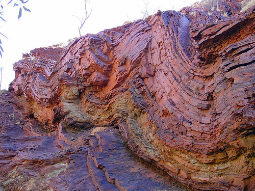
Click on the picture and then again to enlarge it to the maximum, to appreciate the distances shown here, as well as the clearly water-sculpted shapes, including the mud pillows in the foreground. The gouged-out canyons are better seen in the picture at the bottom of the post. All global flood evidence for sure.


=============================================
Del Tackett of the Truth Project has a blog entry today about Why I believe in a global flood. He covers all the elements of it pretty well. I wish he hadn't allowed for the possibility of an old earth, which plays havoc with scripture, and I wish he hadn't ended by saying that he knows some don't believe but "that's OK." How is it OK not to believe what God said? Anyway, the blog covers the main reasons for belief pretty well.

Here are the geological reasons he gives:

-All over the world there is clear evidence of a global flood. Huge, vast sedimentary layers cover the earth. I’ve seen them in Israel, in South Africa, in England, everywhere.

-Fossils represent creatures that were buried rapidly, not slowly.

-The sedimentary layers are laid down on top of each other in tight layers just as we see in hydro-sorting as occurred at Mt. Saint Helens and in the lab. The layers do not show signs of erosion or long periods of time between them.

-Smooth bending or “folding” of sedimentary layers show that the layers were soft, not hard and brittle.

7. The standard geological story doesn’t fit the observations.

-The story that the land sunk and was covered with a large placid ocean in which particles of sediment slowly built up on the ocean floor, then the continent rose and the sediment became hard, then the continent sunk again and a placid ocean covered it with more sediment, then rose, then sunk, rose, sunk, rose, sunk, etc. to form all of the layers defies the evidence and even my imagination. The Redwall limestone layer is 550 feet thick throughout the Grand Canyon. Picture a large placid ocean. Where did all of that sediment come from to form this layer? The Coconino Sandstone layer is 350 feet thick. The Hermit Shale is sometimes 1,500 feet thick. That is a lot of particles over vast areas that had to somehow sprinkle itself over the bottom of the ocean for millions of years.

-I’ve mentioned the fossils, but plants and animals don’t normally fossilize over millions of years. Instead, they decay. This is especially evident when we find fossils like bees whose wings are exquisitely preserved, or fish in the process of eating another fish or an ichthyosaur giving birth when it was rapidly buried.

-The use of radiometric dating of rocks is suspicious to me. Fossils that should be void of any carbon-14 because of their “old” age, are still full of carbon-14. The great assumptions that provide the foundation for radiometric dating leave it ripe for miscalculations.

-By the way, look at the picture here. Notice how the the earth has been vacated, not because of a river. It just looks like someone pulled the plug on all the water and it just washed big caverns in the earth.


[Click on it, and then again, to enlarge it to the maximum]


Much later note (October 2010): I keep coming back to look at the two pictures in this post. They are at least as good evidence for the Flood as the Grand Canyon, and in a way more obviously so. Consider the buttes and cliffs in the background, rising from the relatively flat surface into which the canyons in the foreground are cut. That flat surface is reminiscent of the Kaibab plateau that forms the upper rim of the Grand Canyon which is also smooth and relatively flat for hundreds of miles in all directions except where uplifted by volcanic action and earthquakes. This flatness is the upper surface of one of the layers that were previously laid down in the earlier stages of the Flood, the layers above it having been gouged out and washed away in a later phase of the Flood as the waters were receding. Those upper layers had to have climbed at least to the current height of the highest butte, and probably much higher as layers above them were no doubt also washed away. So the buttes indicate that the entire area was at one point completely covered to quite a depth of layering, then a great deal of it washed away and the last of the flood waters carved out the striking canyons in the pictures, leaving only a meandering river.

Monday, May 31, 2010

The proper way to teach geology

Just as evolutionist biology does, evolutionist geology also presents its mystifications -- its fictions -- as its subject matter, instead of the simple observable visible phenomena it supposedly studies. Just as we can hardly find a simple description of a new species without a thick fog of interpretation about its alleged evolutionary history obscuring the simple facts, so we can hardly find a description of a fossil find or a rock formation without its being obscured by pronouncements of its supposed age and supposed history, all interpretation, all fictive.

If it were possible to talk to the believers in evolution about creationist ideas without always having to debate, being misunderstood in the most zany ways, and being subjected to abusive namecalling and accusations, I'd just like to talk about the basic facts, the phenomena involved, the observable phenomena, completely apart from the interpretive schemes. What sort of rocks are to be found in a particular area, what sort on the surface and what sort at some depth if known, and what sort surrounding it. That would be a start to an understanding of the geology of the area. I don't want to know its "age," and I don't want to know how it supposedly got there. That's all theory, interpretation and in the end nothing but fiction. I want to know what IS there.

You can't even find a geologic map that shows this, they all label the geographic areas as "time periods" instead of observable visible phenomena.

Here's a case in point and this is an older map so not as bad as modern ones. I link it because it's nicely detailed.

It's utterly meaningless to have a section of a map set off in a boundary labelled "Jurassic" or similar designation. It's mystification, the opposite of edification. The first thing you should get from geology is an accurate picture of what actually exists, and the maps should reflect that.

I haven't even been able to find out what physical phenomena are included within the boundary lines in any consistent way. Here and there are discussions of particular rocks associated with particular "time periods" but there's no systematic treatment of the rocks as definitive of separate areas that I've been able to find. In any case that's where any geological discussion should start, it shouldn't start with the purely fictitious time periods and then later add some information about the actual geology of the place.

I don't even know if the boundary lines in any way mark off topological distinctions, altitude differences (they'd have to be rather slight differences since official topographic maps show a maximum height of around 1400 feet for Britain). What DO they mark off? Distinctive rocks? Different altitudes? Layers? What? Are layers in any sense visible in the terrain? The time periods of course suggest stratification, but I want to be able to SEE what their boundary lines are meant to describe. And isn't this what a beginning student of geology SHOULD want?

===========
Some references for future consideration:

A study of the geology of Britain written in 1878

And here's a story about creationist geologists. I'm SO glad these guys exist and are out there looking at the actual world apart from the mystifications of establishment science.

Sunday, May 2, 2010

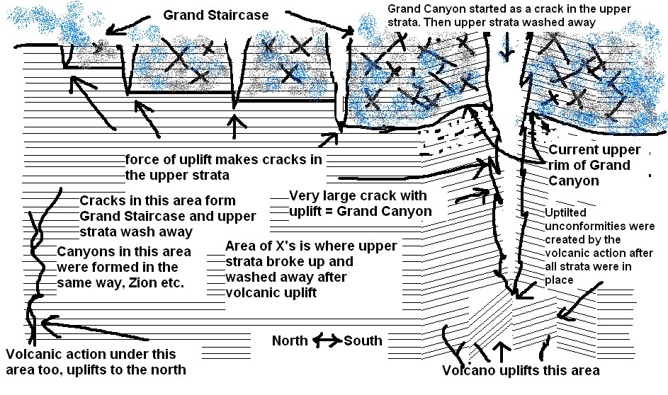
The strata were there first. THEN they were pushed up or buckled or eroded


Strata in mountains


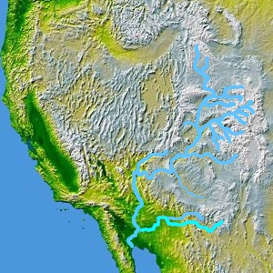
Paths of draining Flood waters through Grand Canyon area


Drainage area of Colorado River and Great Basin


See fingers of magma beneath the area. Volcanic action AFTER the strata were laid down tilted the unconformity at the base of the canyon beneath all the other strata already in place.


This shows how the layers are described as time periods, limestones, shales, sandstones all characterizing PERIODS OF TIME.

Here's my sketch of what I think really happened