
 Siccar Point, Scotland, is where James Hutton decided that the Earth had to be very old and set the ball rolling for that to become the standard assumption of geology, overturning all previous assumptions of a young earth. His conclusion was that the more-or-less horizontal rocks on top of the vertical rocks had to have been laid down long after the vertical ones were in place, as it would take a huge amount of time for the lower to have been laid down, then tilted upright, then eroded before the upper were deposited on them. This kind of formation is known as an angular unconformity and it is considered to be lethal for Young Earth Creationism.
According to Wikipedia:
Siccar Point is a rocky promontory in the county of Berwickshire on the east coast of Scotland. It is famous in the history of geology for Hutton's Unconformity found in 1788, which James Hutton regarded as conclusive proof of his uniformitarian theory of geological development.And according to a University of Wisconsin article:
One day in 1788, he and some friends rented a boat and sailed along the coast, discovering the rocks here at Siccar Point. The younger sandstones are resting atop vertical beds of older rock. The older rocks must have been deposited horizontally, tilted, eroded, then buried by the younger rocks.As I recall from a biography of Hutton he was familiar with the formation already but he and his friends went out looking for it to verify the theory he was concocting in his head about it.
As the theory has it, "the older rocks must have been deposited horizontally, tilted, eroded, then buried by the younger rocks."
The vertical rocks are now known to be about 425 million years old and were deposited during the Silurian Period. They were tilted during a mountain-building event caused by the collision of North America and Europe. In North America the collision created the northern Appalachians. In Europe it is called the Caledonian Orogeny (Caledonia is the old Latin name for Scotland.)The mountains were eroded flat and the younger rocks were deposited during the Devonian Period about 345 million years ago, about 80 million years later.I accept the explanation that it was tectonic movement that caused the tilting of the lower layers, the same movement that built the Appalachians, but I believe it was the jerky breaking apart and pulling away of North America from Europe that did it, as well as the volcanic eruptions that brought about the split, not a collision. There is plenty of evidence of ancient volcanoes in Britain and western Europe as well as along the east coast of North America.
And the theory is reiterated: "The mountains were eroded flat" and new horizontal strata were laid over them some 80 million years later.
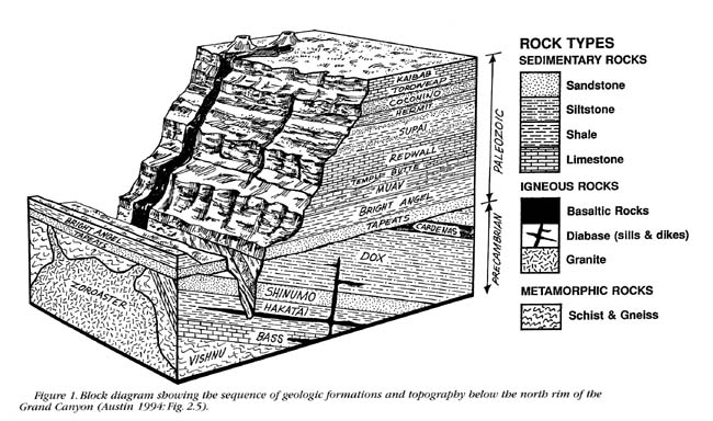
...The contact at Siccar Point is called an angular unconformity, a place where an interval of geologic time is not preserved, and where the lower rocks have been tilted so they form a sharp angle with the overlying rocks. Hutton's Unconformity at Siccar Point is one of the most spectacular examples in the world as well as being of great importance in the history of geology.Here's a diagram of The Grand Canyon showing the angular unconformity at its base.
Here's a page showing a few of the famous angular unconformities. The theory is affirmed in the description of the Entrada formation:
This unconformity (a buried erosional feature) formed when folded rocks of the lower formation (Entrada) had been eroded to a relatively flat surface before the sandy basal conglomerate of the Morrison formation were deposited on and buried this erosion surface."A buried erosional feature."
Here are some animations of the current theory about how angular unconformities are formed:
Exploring Earth Visualization.
There are two series of animations on this page that include the formation of a nonconformity as well as an angular unconformity.
And here's another animation of the angular unconformity
The sequence is identical in all cases. You see the buildup of horizontal strata, then the tilting of the strata, then the erosion of the surface to a relatively flat plane on which new horizontal strata are built.
This online book Telling Geologic Time, is nicely done and gives some clear illustrations of the current theory. The following diagram comes from this book and includes the same steps as in the above-noted animations of how angular unconformities develop.

This diagram shows the theoretical erosion part of the process, the erosion of the buckled strata more or less flat. Again, the process as current geology visualizes it it involves the laying down of flat horizontal strata, followed by a buckling of the strata, followed by an erosion of the surface that more or less levels it, followed by the laying down of more flat horizontal strata.
MAIN OBJECTION TO THIS THEORY: COGNITIVE DISSONANCE HERE: SINCE WHEN DOES EROSION EVER RESULT IN A FLAT PLANE SURFACE? Even a "relatively" flat plane surface? Since when would erosion reduce a mountain or a buckled block of strata to a plain?
The diagrams based on the theory all show a leveling of the elevated parts of the buckled strata. The idea seems to be that even mountains are ultimately eroded utterly flat, like a plain, so buckled or tilted strata with all their protuberances are expected to have been eroded down to flatness.
In what universe?
ON THE CONTRARY, erosion follows gravity, making paths down hills from summits, carving stream beds and gullies, transporting rocks and other debris and depositing them hither and thither, even in this way transforming plains into pocked and pitted and lumpy bumpy terrain, the OPPOSITE of what is claimed by these diagrams. Erosion also has an easier job of it with soft rocks and not so easy with hard ones -- and strata contain both soft and hard rocks. No way normal erosion is going to neatly scour away a stratified mountain to a flat plain.
Funny how they assume that erosion would level the buckled strata and yet at the same time they believe an ordinary river carved the Grand Canyon. This is really quite funny.
The only time erosive processes would ever produce a plain would be in such a massive event as the Flood of Noah, when huge areas of the higher strata would break up under tectonic or volcanic disturbance and be scoured off the surface of a particularly hard lower layer by the receding Flood waters. This is what appears to have been the case with the formation of the Kaibab Plateau that extends from the rim of the Grand Canyon to the base of the Grand Staircase, and other parts of the Southwest where some remnants of the upper strata remain in the form of buttes and odd "monuments" and hoodoos and the like, while the surrounding terrain is flat.
 But normal-sized rivers, even little streams, just cut gullies and deposit rocks and other debris that disturb flatness. Just happened to find this photo of erosion of the cliffs of Dover on Wikipedia: I think it makes the point.
One absurd idea that comes from this absurd theory is that the Appalachian Mountains are "older" than the Rockies or the Himalayas, even that the Appalachians were "once higher than today's Himalaya mountain range."
No, they are different kinds of mountains. Both formed by tectonic forces no doubt, but the Appalachians are rather gently buckled compared to the Rockies, which appear to have been abruptly thrust up toward the sky in one massive movement that often preserved the strata's straight parallels if not their horizontality. The Himalayas also show such a cataclysmic origin, though I can't even find strata in pictures of them. The Appalachians never had jagged peaks that supposedly eroded away. Their strata are often gently buckled into anticlines and synclines. No amount of erosion would turn the Rockies or the Himalayas into Appalachian type mountains, and no amount of erosion could reduce the Appalachians to a flat plain either.
But that's of course a side trip.
BUT ALSO, WHY DOES STRATA-BUILDING STOP AND EROSION BEGIN?
Another question that occurs to me is why they so consistently assume that after the buckling of the strata there MUST be a period of erosion? Why? Why doesn't the laying down of sediments continue as usual? What magic wand was waved to stop that process? If the erosive period continues for as long as 80 million years, as apparently it's supposed to have done in the case of Siccar Point, before new strata are formed over the old, why aren't strata being formed during that 80 million years as well? What is it that would suddenly trigger erosive processes to the extent of being able to wipe out mountains in place of the usual processes of strata building? If strata just simply continued to be formed after the buckling of the previous strata then the new sediments would fill in the spaces in the buckled strata first. I'm not even sure there is such a formation anywhere to be found on the planet.
As there shouldn't be according to Flood theory, which shows that all the strata were put down at one time and buckling and other distortions occurred afterward.
Just another way the current theory makes no sense.
[Realized later that they assume the strata were laid down under water, tilted under pressure, then the land was lifted above the water and that's when the erosion began and the deposition of strata stopped. This raises its own questions but I realize it's at least necessary to acknowledge this much.]
SO HOW DID THE ANGULAR UNCONFORMITIES FORM?
1) All the strata had been built by the Flood.
2) A tectonic force from the side or a volcanic force from beneath (in the case of the Grand Canyon) tilted or buckled a block of the lower strata WITHOUT DISTURBING THE STRATA ABOVE THEM. Slippage between layers of different kinds of rock would facilitate such a movement, softer rock buckling under harder rock for instance. In the case of the Grand Canyon the volcanic force raised the whole area so that the higher strata follow the shape of the mounded elevation into which the canyon was cut, but even higher strata that were once there were cracked and broken by the force and washed away in the flood waters, leaving the Kaibab Plateau as the uppermost layer, a hard layer of limestone. Underneath, the volcano displaced the lowest strata which were met by the counterpressure of the heavy upper layers and simply tilted beneath them, creating erosion by the friction between them and the layer they are sliding under.
Same thing certainly happened at Siccar Point and other angular unconformities. One thing to notice about Siccar Point is that although a difference of 80 million years is assumed between the lower vertical and the upper horizontal layers, they look identically weathered and eroded. Speaking of what erosion is supposedly capable of, according to current theory, you'd think the entire block of vertical strata would have been reduced to the supposed flat plain well within the 80 million years allotted to it before the upper strata were deposited. At the very least they should look a lot more spindly and splintery than the upper strata in such a time frame.
TO BE CONTINUED.
No comments:
Post a Comment
PLEASE just register somewhere, there seem to be many options. A Google account is easy. And give SOME kind of pseudonym at least. THANKS!